- About Ukraine
- The Name of the State
- Geographic Situation
- The Land
- Natural Resources
- The Seas and Inland Waters
- The Climate
- The Flora
- The Fauna
- Administrative and Territorial Organization
- The Population
- Kyiv
- Folk art from Ukraine
- Love Ukraine
- Ivano-Frankivsk region
- Hutsuliya
- Rest and Tourism
- Photograph Album
- Library
- Feed
- Store
95% of Ukrainian land is formed by plains and about 5% — by mountains (Carpathian mountains in the west and Crimean mountains in the far south). Horizontal zones (belts) of Ukraine change from north to the south, from mixed forests to plains.
Mixed forests cover the north and stretch from east to the west for more than 750 km (Ukrainian Polissiya). Almost 45% of the lands are farming grounds, 30% — forests, 20% — hayfields. The zone of forests and plains (steppe) stretches from the southwest to the northeast for almost 1100 km. This is land of intensive farming — forests taking up only 12% the rest are fertile soil.
The plains cover almost 40% of the land. From the southwest to the northeast it stretches for almost 1000 km and is nearly 500 km wide. Farm lands take nearly 75%, forests — only 3%.
Ukrainian Carpathians and Crimean Mountains belong to the vertical zones (belts) of Ukraine. The forests take up from 15 to 50% for Carpathians and five different belts of vegetation are defined. Crimean Mountains take up more than 1/5 of the Autonomous Republic of Crimea. The forests reach 10% but there is a lot of other vegetation.
 Carpathian Mountains
The southern shore of Crimean peninsula is a narrow (2–12 km) line on the south side of Crimean Mountains that stretches 150 km from Cape Aya in the west to Cape Illya in the east. This is a popular recreational zone for Ukrainians and foreigners. Zmiyinyi island that is situated in the Black Sea 120 km to the south of Odessa is another part of Ukraine. It’s territory is 1,6 square km, its highest point — 41,3 m.
Ukrainian plains are not level but include up- and lowlands. The uplands include: Peredkarpatska (650–800 m), Volynska (220–300 m, highest point — 342 m), Khotynska (350–400 m, highest point — 515 m); Pryasovska (150–300 m, highest point — 324 m) with unique natural heights — “graves”. The lowlands include Polisska, Prydniprovska, Prychornomorska, Zakarpatska and the Crimean plains.
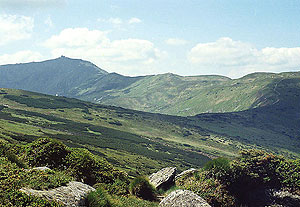
Two mountain systems — Carpathians and Crimean Mountains form a stone necklace of Ukraine. Ukrainian Carpathians stretch in a line wider than 100 km and 280 km long. The highest area is Polochynsko-Chornogorskyi range (Goverla Mountain — 2061 m, Pip-Ivan Mountain — 2022 m, Petros Mountain — 2020 m). The average height of the ranges is 700–1700 m. The passes are not high and relatively easy and therefore widely used. There are gas and oil pipes, electric lines, roads and railways here.
Crimean Mountains stretch along the south shore of the peninsula for 180 km and are about 50 km wide. Average heights are 700–1200 m. The mountains consist of three parallel ranges Main (Southern), Inside and Outside (Northern). Southwestern and central parts of the main range are formed by almost forestless areas called “yaylas”, including Baydarska (500–700 m), Nikitska (1300–1500 m), Babugan-yayla (Roman-Kosh mountain — the highest in the Crimean Mountains — 1545 m) and others. There are many caves and wells here.
The inside range stretches in a line from Inkerman in the Old Crimea and its highest point is Kubalach mountain. The outside range includes some low mountains and ranges. On the southern shore of Crimea there are mountain amphitheatres of Alushta, Yalta, Gurzuf and others. Unique uneven and complicated plains distinguish Kerchenskyy peninsula.