- About Ukraine
- Hutsuliya
- Hutsulshchyna
- Kosivshchyna
- Kosiv
- History and Borders
- Pearl of Hutsulshchyna
- Small Paradise
- Jews of Kosiv
- Yavoriv
- Kosmach
- Kuty
- Yabluniv
- Rozhniv
- Rest and Tourism
- Photograph Album
- Library
- Feed
- Store
The administrative and cultural center of the district is the town of Kosiv. The first written mention of it is in the Grant Charter of Prince Svydryhaila Vlady Drahasynovycha, on September 31, 1424. At that time, the village was in the territory of what is today Old Kosiv. In 1565, near the slattern, not far from modern-day Kosiv, Snyatynskyi Starosta Tenchunskyi founded a town named Rukiv. Sir Yazlovetskyi, the head of Kuty, later destroyed it. Some years later, the town was recovered and named Kosiv (the earlier village of this name thus became Old Kosiv). Since 1867, Kosiv has been the center of the Kosiv District. From 1934 to 1939, the town was called Kosiv Hutsulskyi.
Until 1772, Kosiv was under Polish control. After this time, it was occupied by Austria. From 1919 to 1939, it was again under Polish control. In 1939 Western Ukraine became part of the Union of Soviet Socialist Republics (USSR); however, from the first of July 1941 until the second of April 1944 Kosiv was under the control of fascist Germany. After that time it was, again, a member of the Soviet Union.
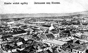
Today, the town of Kosiv borders on the towns and villages of Babyn, Horod, Smodna, Cherhanivka, Staryi Kosiv, Verbovets and Pistyn. The distance from the railroad station in Vizhnytsa is 12 kilometers, from Zabolotiv is 25 kilometers and from Kolomya — 35 kilometers. Roads with all neighbouring districts connect the city. The total length of roads is 362 kilometers. 160 kilometers of these roads are paved.